February’s weather went largely as expected based on our previous weather watch, but there were some differences seen across the country.
For around a five-day period at the start of the month, temperatures were above average - feeling a bit more like mid-to-late March rather than February. These mild spells came with more frequent rain, however, and with high pressure often lurking nearby, this kept some areas dry and sunnier than normal. Southern England saw very little rain, in what should be one of the wettest times of the year. Berkshire saw a mere 2.7mm for the entire month, making it the driest February since 1934. Rainfall for the north of Scotland was a little on the dry side, but closer to normal.
For March, two major weather events are taking place that are throwing a fairly large spanner in the works and making the atmosphere extra-unpredictable. The first is something called a sudden stratospheric warming, which is occurring over the Arctic at about 10,000m above sea level. This is helping to destabilise the mid-latitude weather patterns and is giving us a cold snap for early March that should last for around a week, causing some snow in places and temperatures well below average while bringing a brief blast of winter back into the start of meteorological spring.
In addition, some extra thunderstorm activity may develop near Papua New Guinea and Micronesia. This might seem too far away to affect us much, but it certainly can. At this time of year, we can expect more high pressure systems moving into northern Europe from this signal, but usually delayed by a couple of weeks.
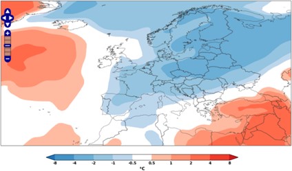
Overall, we expect March to see a weather pattern that we call “polar blocking”, which sees high pressure in Greenland and the Arctic Ocean to the north of Europe. This high displaces low pressure over the continent, and brings Europe wet, unsettled, and generally slightly cold weather. The sudden stratospheric warming event is making early March colder still, and likely the coldest week of the whole month. The tropical thunderstorms are adding some uncertainty to the back half of the month and might bring in more changeable weather to break up the monotony.
Forecast confidence isn’t terribly high due to all these signals amplifying the volatile nature of the atmosphere, but a slightly cold, unsettled March looks likely, with a growing chance for some mild, dry, sunny spells later on.
About this author
