December 2022 will be remembered for its cold wintry weather, but this was the exception being the only month in the UK last year with an overall below average temperature anomaly. In fact, the Met Office recently declared 2022 as the hottest year in the UK since records began in 1884.
The extreme cold of the first two weeks of December were the coldest in the UK since the winter of 2010 (source: Met Office). This was caused by Northerly winds drawing some very cold air down from the Arctic. The cold was brought to an end not long before Christmas as the winds shifted to Westerly, which also set up a warmer than normal start to January and 2023.
We can expect more of what’ve we had these last few days in the short-term and for the rest of January, so plenty of wet, breezy and changeable weather, but generally feeling mild. This is thanks to, no surprises here, a more active jet stream.
With a powerful jet stream more low pressure systems are pushed across the Atlantic and over the British Isles. A low pressure dominated weather pattern tends to bring more unpleasant weather in the form of organised rain bands along fronts as well as showery, breezy, grey, and cloudy weather.
The temperatures are looking on the warmer side of normal for most, thanks to the prevailing wind direction being Westerly to South-Westerly, although Scotland and far Northern areas are forecast closer to normal. Some colder days and nights are expected in between the milder weather, but these should be short-lived. The potential for colder spells does increase as the month goes on so that’s something to keep an eye on, but the signal for near normal/milder temperatures during the first half of January is strong.
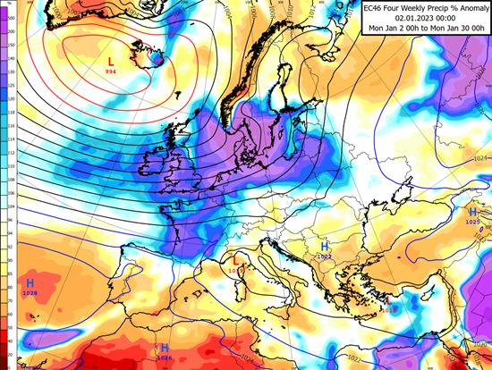
The map above shows forecast precipitation anomalies for the month of January over Europe. The blue and purple shading over the UK and Ireland clearly suggest a very wet January, typical of an active jet stream and a low pressure dominated pattern. We can also see that the high pressure centres (labelled ‘H’) are well away from the British Isles, allowing cloud and rain to roam more freely. It’s important to remember that this map is an average for the month, so in reality we will see drier spells between fronts and glimpses of high pressure, though it does give a good overall guide.

