
We didn’t follow much of the world this July here in the British Isles; the daily average global temperature was broken three times in a row last month and the World Meteorological Organisation expect July 2023 to be the hottest on record. Some of this heat wasn’t too far away - Southern Europe had multiple spells of extreme heat and plenty of sunshine which eventually led to wildfires in Greece.
Meanwhile in the UK, after four weeks of cooler, wet, and blustery weather many of us are questioning where the summer has gone this year. And rightfully so, provisional statistics for the UK from the met office have July 2023 as the sixth wettest July since 1836!
This begs the question, is it too late for summer to make a return? The answer is most likely, yes. The atmosphere has been consistent with the current large-scale weather pattern lately with the jet stream dipping South and keeping low pressure around North-Western Europe. The computer models have been persistently forecasting for this to continue for the next two to three weeks.
Later next week high pressure could pass by, briefly dropping the windy and wet conditions however, this shouldn’t bring any heat that’s too significant. The high could end up hanging around a bit longer, although continental Europe has better signals for this in mid-late August. Overall, the risk for heatwaves and more persistent spells of sun are looking low for the UK.
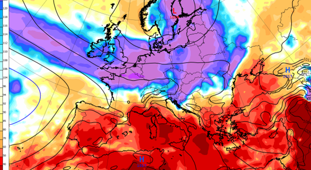
The map at the top of the page has a four-week precipitation anomaly forecast covering most of August, although much of the wet weather falling this week is skewing the anomalies, it does demonstrate the general expectation for a drier than normal Mediterranean and wetter than normal Northern Europe.
The end of the month and heading into September is more of a question mark, and we could see a pattern shift in which high pressure acts as a block in Northern Europe. Some better chances then for a warmer and drier pattern for the British Isles, but uncertainty remains.
Outside of Europe, across other parts of the Northern hemisphere, August is generally looking less extreme than the heat of July. Warmer anomalies should continue though, typical of the ongoing El Nino phase of the El Nino Southern Oscillation (ENSO) system in the Pacific, one of the most important drivers of weather and climate variability.
About this author
