6 September 2023

After a largely cool and wet summer, we’re finally able to bask in some summer-like sunshine and heat this September, but will it last?
Although not as significant as July, August brought a cool end to the summer for most. Preliminary data shows that on average it was another below normal temperature month for the UK. This was particularly the case for England and Wales, with Scotland running a bit closer to normal. Sunshine and rainfall were variable through the month.
Reduced certainty in model forecasts is the highlight for this September, which is typical of early autumn due to the Atlantic hurricane season. Tropical activity was initially expected to be suppressed this season due to the ongoing El Nino phase in the Pacific Ocean, however, a combination of weather patterns lined up recently to create ideal conditions for tropical cyclones to form across the mid-Atlantic Ocean.
Computer models can struggle with forecasting these weather systems at range, which in turn has the same effect downstream for the weather over Europe. So, forecasts beyond a week are likely to fluctuate more than usual.
These tropical cyclones can also track Eastwards over the Atlantic. They usually fall apart by the time they’ve reached Europe, but when this does occur, they can drive the large-scale weather pattern. For example, ex-hurricane Franklin, which is currently a few hundred miles North of the Azores, is helping transport this week’s heat into the UK from North Africa.
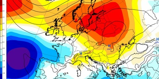
This can be seen on the map above, a 4-week forecast of sea level pressure anomalies, by the dark blue shading West of Portugal showing the remnants of ex-Franklin which in combination with high pressure in Northern Europe (orange shading) is circulating the hot Saharan air into Western Europe.
The hot, dry, and sunny weather so far will continue across the UK the next few days, though by next week there are signals for a milder air mass to push in from the North-West and moderate the temperatures. A general trend to more unsettled and wetter weather due to more frequent low pressure around the British Isles is the likeliest scenario for mid-late September. The temperatures would be more changeable in this case, but generally near normal for this time of year.
However, there are big questions marks around this, and it will depend on what happens with any hurricanes, among other factors. There is the chance that this heat sticks around longer or for a similar pattern to repeat again later in the month. For now, we can enjoy some much needed sunshine.

