
October panned out largely as expected with plenty of wet and blustery but generally mild weather. A near-constant supply of oceanic air from the Atlantic kept things warmer than normal for mid-Autumn, with some days above average by more than 6C and temperatures of over 20C were recorded across Southern and Eastern England as late as the 29th October, which is significant considering we’ve only just entered the final month of Autumn.
A continuation of this mild, unsettled pattern is the story for the beginning of November with chances for some more settled and dry but colder, weather increasing later into the month.
Things have already cooled down from a warm end to October, but the unsettled weather is showing no signs of going away for now.
The current weather pattern we’ve seen so far for November will continue this week with passing weather fronts bringing heavy bands of rain and showers to all areas of the country. Some clearer and drier spells, sometimes lasting a day, will squeeze through in between the cloud and rain. Although it will be cooler than we’ve seen recently, some unseasonably warm days are still forecast; upper-teens in Southern England and low-mid teens for central Scotland. The overnight temperatures will be particularly mild for many as well.
This pattern is thanks to an active jet stream and low pressure being dominant over the British Isles. As we move further into November however, there are signs the jet stream may weaken and allow high pressure to build in closer to the UK and do so more frequently. This would lead to more settled weather as weather fronts are steered away from the centres of high pressure, so generally less cloud and rain. However, high pressure this time of year can often mean colder weather, especially if the high centre is in the right place to blow in colder winds, say from the North.
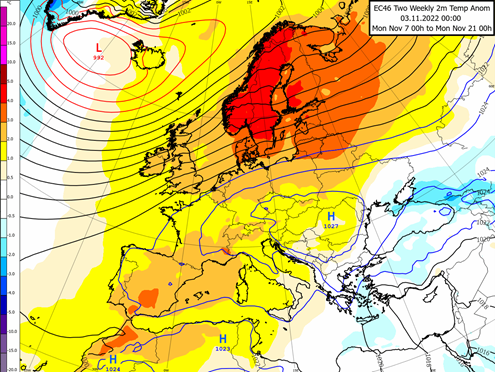
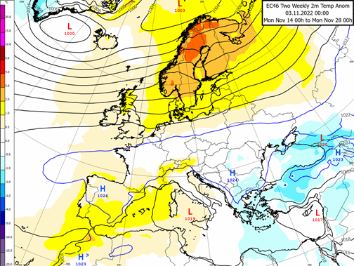
The likelihood of this increases later in November and even more so into December. Below this article you can see the two maps of temperature anomalies (temperatures compared to normal) which show this split. The first map is for the first half of November in which yellow shading across the UK indicates warmer than usual weather, whereas the second map for the latter half of the month has lighter shadings of yellow indicating that things will get colder.
Even if the pattern of a weaker jet stream with more high pressure fails to gain momentum, the temperatures should gradually get colder to near-seasonal levels for late Autumn, as we lose any available sources for heat this late in the year.
Look out for the next Weather Watch which will be the first of the Winter.
About this author
