
After a mild November, a colder than usual December has already felt like a bit of a shock and it's only going to feel increasingly wintry.
November was generally warmer than normal for typical late autumn, the temperature anomalies for the month were +1.4C for London and +1.25C for Glasgow and a lower number of frosts were recorded than usual across the country.
As soon as we hit December the thermometer readings began to drop. This was thanks to an Easterly wind that developed bringing in a colder air mass from Russia and Scandinavia. Later in the winter season this setup can lead to extreme cold conditions for the British Isles along with widespread snow; earlier in the season this weather pattern tends to be less extreme.
A Northerly wind in December is indeed very cold and that happens to be the wind direction developing this week and into the next. As such the Met Office has already issued a yellow warning for snow in Scotland and more can be expected to come.
It’s not looking particularly wet for most of the UK in the shorter range, but some wintry showers for Northern and Eastern areas are likely, especially along the coasts.
Widespread frosts are also on the way with low temperatures consistently dipping below freezing for most this Wednesday until next Tuesday. Afternoon highs barely above 0C are forecast this weekend which is as much as 9C below average for some areas.
Some milder air may eventually move in later next week, though if this does turn out, it’s likely to be combined with wetter and more unsettled weather.
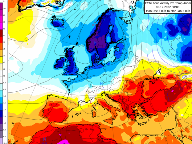
The map above shows the four-week forecast temperature anomalies for Europe for the remainder of December. We can see a clear battleground region in France and central Europe between cold to the North and milder air around the Mediterranean and South-East Europe. (It’s important to note that much of the anomalies seen here are being driven by the very cold weather this week and early next week.)
Much of the weather this month, including the very cold Northerly flow beginning this week, will be driven by a strong Greenland high pressure system which is helping shift the jet stream further South. This keeps us on the colder side of the jet and any mild air from the Atlantic transported along low pressure systems is pushed away towards South-West Europe.
The Greenland high also helps force air off the Arctic ice sheet down into Northern Europe and the British Isles, which is what we are seeing this week.
Looking further ahead, towards Christmas and New Year, we generally expect more of the same; cold, frosty weather but often settled and clear when showers aren’t around. The potential for more unsettled, wet, and milder weather does increase as the month goes on and into 2023.